And now for something not specifically thru-hike related.
Long-time readers might recall my doing a film shoot with a documentary crew last October. If not, click here.
I had been waiting all summer to hear about an airing date. I did have some contact with the producer, but found out from friends that it had aired.
Photo of a screen courtesy of Eric Allen.
I had hoped for the advanced notice so I could get the word out.
So here is the advanced warning for the rerun, as listed at The Travel Channel:
Columbia River Gorge
Kayakers Rush Sturges and Evan Garcia ride treacherous whitewater rapids and waterfalls along the Columbia River Gorge, explorers enter Mt. Hood’s mysterious caves, and Bill Anders voyages to the natural wonder of Crater Lake.
TUNE IN FOR THIS EPISODE
SUNDAY September 20 7am | 6c
Even that description has me wondering about the content of the show, since we were doing trail work on the Rim Trail above Crater Lake.
Here’s a trailer for the episode. I am the second voice-over. The editing is interesting, since the whole time I was discussing Crater Lake specifically, since that was our focus that day. But I would not disagree with using it to cover the whole state.
If the embed code doesn’t work, just copy https://www.youtube.com/watch?v=SvM1_JDPTug and paste into your browser address field. For you literalists, then press the return/enter key.
____________________________________
Please remember that although this trail work is performed mostly by volunteers, the work is not free.
We have walked about 1,900 miles of this 2,650 mile trail, but are still shy of half of our goal for this hike – to raise $4,000 for the Pacific Crest Trail Association (PCTA). The PCTA is the organization responsible for planning, organizing and executing trail development, maintenance and recovery along the entire trail.
If you’d like to continue to see this quality programming…
For long time readers, you know that I typically run a Summer Solstice sale over at my photography site – Bill Anders Photo.
For those of you new here, that’s what I do.
But not this year.
Instead, all I ask is that you consider supporting our fundraiser for the Pacific Crest Trail Association (PCTA), the organization to oversees and coordinates protection and maintenance of the PCT.
Our goal for this year is to raise $4,000. We’re currently sitting at $1,595, just under 40% of our goal.
If you’re enjoying the stories that the trail provides, please consider donating through our Razoo site – http://tinyurl.com/le5cu9j – where the minimum donation is just $10. Since the PCTA is a 501(c)(3) non-profit organization, you may be able to deduct your donation on your 2015 taxes (US residents only).
Every little bit helps.
If donating to the PCTA isn’t your thing, please consider instead our local trail advocacy organization, the Siskiyou Mountain Club.
Gabe Tenor runs a very small operation that works to protect and maintain trails in the southwestern Oregon and northern California, including several Wilderness areas.
Another 501(c)(3) non-profit organization, the SMC is looking to raise $7,000 by July 1st to fund interns for the summer to restore 30 miles of trail in the Wild Rogue Wilderness. At last report, they have raised just over $5,200. Again, every dollar helps.
It has been a crazy week since we’ve moved out of the house. But it has all been good.
In a nutshell, we tied up a few loose ends in Oregon and headed south.
We spent the weekend with our resupply goddess getting a late delivery of food put together;
We drove south through California’s central valley. We were planning on taking a couple of days to get to San Diego, but got word that there were just a handful of spaces left at our planned auto storage facility that were first-come, first-served, so we pushed hard to get there and get our spot. We did;
Then it was last-minute chores of sending out resupply boxes and getting everything ready. But since San Diego is my old stomping grounds as a teenager and Jennifer has never been here, there was food to be enjoyed and places to see.
In case you weren’t out traveling earlier this month and missed getting a copy of USA Today slid under your room door, there was an interesting article on the state of the National Forest Trail system, which is pretty dismal.
One thing you’ll notice in the article is the increasing reliance on volunteers to maintain the trails.
We’re eager volunteers. Personally, I enjoy the excuse to get out into the wilderness and do some work. The crew members are great and everyone’s excited to be there to work.
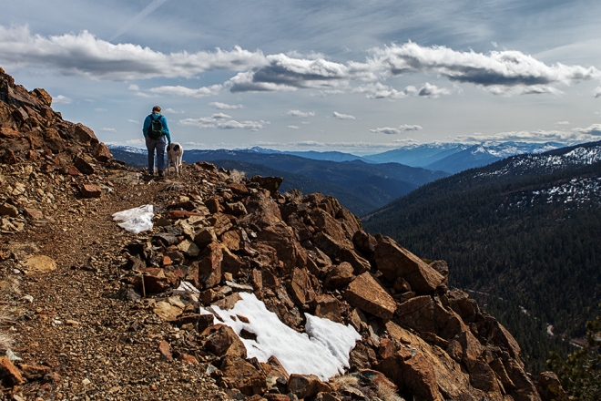
Plus, for me it’s a chance to see new areas and scout out where I’d like to return to shoot photos. Like this one.
For me, it’s a win-win.
As much as we’d like for the work to get done on its own, just through the love and dedication of the volunteers, it can’t. For many of the volunteers, they sure wish it could, but it can’t.
So please consider donating to the Pacific Crest Trail Association (PCTA), the non-profit organization responsible for the trail-work coordination and execution, as well as the protection of the trail corridor.
The PCTA is a 501(c)(3) non-profit organization, meaning that your donation may be tax deductible on your taxes next year (sorry, if you were looking for an angle on the forms you’re doing now, that ship sailed two months ago).
We are 1/4th of the way to our goal! Would you please help maintain the trail that Jennifer and I will be walking this year? Your help will ensure that the trail is available for hikers in the future too.
Please click on the picture of Jennifer and Skinny on the PCT below to lend a hand.
A trek like this isn’t possible without permits. We cross a lot of public land that is protected for one reason or another, not to mention several National Forests and National Parks. Each requires a permit.
PCT: For the purposes of a long-distance hike on the PCT that is longer than 500 miles, the PCTA manages an interagency permit system that covers the myriad permits along the way. That’s much easier and more efficient than trying to coordinate with all of the different agencies.
Especially to summit Mount Whitney.
Due to the increasing popularity of the trail, they’ve had to institute a 50-hiker/day start schedule. That move caused a lot of consternation amongst many hikers, folks who by their very nature are easy-going and just go with the flow. The new quota meant that we hikers had to pick a date and stick to it. For those that didn’t jump on the registration site right after it opened, their preferred date might not have been available.
That’s a bit problematic for folks that had already bought airline tickets. The system is even getting press in The Smithsonian.
But it’s working out. After the initial consternation, most folks are realizing that the system is the only way to minimize impact on the trail. Our start date is already full, at the beginning of a stretch of two weeks where every day is fully permitted. So we’ll see a lot of folks on the trail in those first few weeks.
Campfire: Since we’ll be camping mostly outside of established campgrounds in California, we are required to obtain a campfire permit. It’s a simple system consisting of watching/reading a short fire prevention presentation, then taking a test. A successful test completion means a permit. Done.
Canada: Yep, we need a permit for Canada. Why? The final 9-mile stretch of the trail is in British Columbia, finishing in Manning Park. But there isn’t an official border crossing there, so they need to know we are coming. Plus, we need the official stamps to show that we aren’t in Canada illegally.
That makes sense. Otherwise, I might take away someone else’s job at a Tim Hortons.*
Mind you, we don’t have to go into Canada to complete the PCT. We could stop at the monument right at the US/Canadian border, take our pics and not enter Canada. But that means a 30-mile hike back to the first US town south.
Since we don’t have anything keeping us from entering Canada (e.g., criminal record), we’re going to keep walking.
The added advantage of going into Canada is that a very good friend lives nearby. It will be good to finally meet him on his home turf, as we’ve only been able to get together in Germany and here in the US.
That’s it for permits. It doesn’t seem like much, but the PCT and Canada permits add a bit of stress to the process, as they don’t open for application until so late in the planning. But it has worked out. We’re fully permitted.
*Tim Hortons – my only experience with a Tim Hortons has been their furthest east franchise, a lovely garden spot known as Kandahar, Afghanistan. I must say that they make a fine doughnut. Hopefully I can get another one at the end of the hike and see if it tastes just as good.
There has been a lot of walking around here lately. A lot more than usual.
We do live in quite a walkable town.
But we’ve got a longer walk to get ready for, you know. So it’s a lot more hours on the feet, more frequently.
Today was one of those days, complete with errands and appointments. It helped that our errands and appointments in town today were spread out. That forced us to get walking early.
It was also a great opportunity to test the rain gear that we have on hand (we’re still mulling over a couple of items), plus check to see how the sock/shoe systems work while soaked (verdict: swimmingly).
The best part is that once the appointments were done and we were waiting for the shop to finish with the car, the walk delivered views like this:
We took the rainbow as a sign that our car was done at the shop. Three hours later, we found that to not be true. But four hours later, all was right.
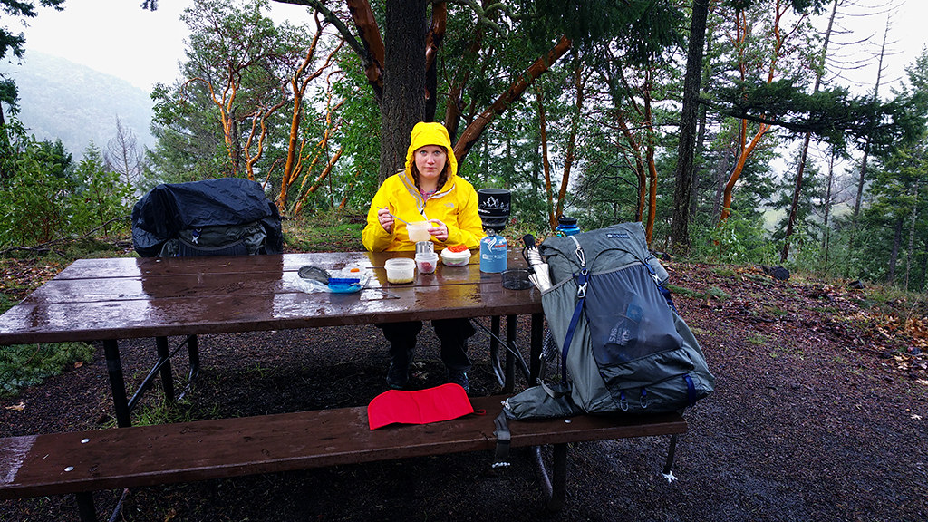
That image was shot right after we stopped for our “lunch”. I put “lunch” in quotation marks because we’re working on our feeding schedule on these walks, trying to stick to every 90 minutes or so for a snack, then keep moving.
This specific feeding was closest to noon, so that counted as “lunch”.
Just 90 minutes later, it was mid-afternoon and it was time for a break. It had been raining pretty steadily and hard for several hours, not to mention all of the water blowing off of the trees in an increasing wind. But we were comfortable.
Just a touch hungry.
As Goddess boiled the water for some hot tea, I snapped a couple of pics, which didn’t stop her from eating some of the salami and rehydrated veggies. But her look here, a look that I did not notice at the time, is proof that if I didn’t act fast, I was not going to get any of it.
The last few weeks have been much more work than play. Although compared to work in years past, this work is still play.
The days are filled with culling and moving the belongings as well as researching and planning for the long walk. Other than cataloging items or recording other items before disposing of them, I hadn’t grabbed the camera in almost a month.
That’s bad.
It was time to get out for a shoot that wasn’t about working. Although it was long walk related.
We drove the approximate route of a possible self-imposed deviation from the Pacific Crest Trail (PCT) that we’re considering taking this summer. It doesn’t really increase or decrease the length of the walk, but might make a minor resupply easier while getting us more consistent access to water on a 30-mile stretch of the trail.
That access means that we’d have to carry less water, which is less weight. But more exposure to mosquitoes. It’s a tradeoff we’ll consider along the way and likely not make a call until we’re back here in Oregon.
All while keeping in mind a quote from a much faster thru-hiker than us when referring to part of the trail that we would bypass:
“As soon as we crossed the highway, it was like walking into a wall of mosquitoes. There were hundreds at a time all day every day. Carry DEET and a gun to shoot yourself with”. – Straight Jacket
And we’re considering a route with more water.
Granted, we’ll be later in the season, around mid-August, when the mosquitoes really die off up near the mountain lakes, but they’ll still be an issue. Perhaps those will be the days that we get in 30 miles per day to just try to get through it.
A bit of manic hiking, perhaps.
Once we covered part of that detour, we hiked, following the PCT north into that bit of what would be mosquito hell in a few months, then turning back south, crossing the highway and hoping to get a good view of Mount McLoughlin. The day had been clear and I was hoping to get some good late afternoon shots of the snow-covered mountains.
Of course, once we got into a clearing, we could see the clouds moving in. Mind you, I like the clouds. They give some interest and texture to what could be otherwise boring.
But these clouds were getting thicker to the west and really cutting down on the sunlight. I rushed ahead, tramping over the crusty snow and bare trail to find a good vantage point. I left Goddess behind and she wasn’t too pleased with that. But we were losing light.
The view turned out OK. Not quite what I was hoping for, but it was part of a few hours out on the trail. That’s always a good thing.
Plus we were able to attend a viewing of a new movie covering the John Muir Trail (JMT), a 210-mile trail in the Sierra Nevada mountains. During our long walk this summer, we’ll cover about 160 miles of that trail, as they share tread.
The movie is a documentary of two ultra-marathon runners who set a “fastest known time” for the trail back in 2013. It just so happens that one of the runners, Hal Koerner, owns our local running shop and is a certifiable badass.
This trailer gives a glimpse of some of the beauty that we’ll be walking through.
In the last post covering PCT Planning, I mentioned a 20 mile-per-day (mpd) average needed for us to get to Canada by the end of September. Hopefully before the snow starts falling.
Twenty miles a day? Walking? On purpose?
Gotcha.
But remember, that’s the average. Half of the hike will be below, half will be above.
We’re going to stick with the ultra-marathon mantra of “start out slow, throttle back”. In other words, we intend on being tortoises.
We’ll start our hike about 10 days earlier than the traditional start of the PCT hiking season, which coincides with an event called the Annual Day Zero Pacific Crest Trail Kick Off (ADZPCTKO). The ADZPCTKO is, in a nutshell, a camping weekend where hikers can meet other hikers, get advice on their equipment, buy what they need and get the latest trail, water and snow conditions for the trail before they head out.
[I actually typed “buy what they don’t need”. Freudian slip, anyone?]
The location of the ADZPCTKO is the Lake Morena campground at PCT mile 20. A lot of folks will do that 20 miles in their first day.
Goddess and I will not.
We’ll take two days to get to that campsite, a week before the masses. We’ll keep moving at a 10 mpd average pace for the next couple of weeks.
There are downsides to moving so slowly. We’ll have to carry more water between watering holes (literally) in the desert. We’ll have to carry more food between resupply points. But we’ll be giving our feet and our bodies frequent breaks during the day, giving everything a chance to settle into the task.
A typical day early in the hike might look like this – wake up early and get on the trail around sunrise. Walk for a couple of hours until mid- to late-morning when it starts to get hot (it will be the desert, y’know). Find or create shade, have lunch, take a siesta and wait until late afternoon. Then get a couple of more hours on the trail in the late afternoon/early evening before setting up camp for the night.
A lot of folks will try to get in 20 mile days, day after day, right from the start. Some of those will soon start to deal with incessant blisters and/or bio-mechanical issues. Quite a few of those will stop at Warner Springs, just 110 miles into the hike, deal with their injuries and never continue.
That’s not something we want to experience.
We’ll get to Warner Springs as the ADZPCTKO is in full-swing and we’ll likely continue north. Although we’re still discussing the possibility of hitching a ride back down to the event. We’ll have time.
If we continue along the trail, the fast hikers will catch up to us within a few days. Soon the trickle of hikers will become a steady stream as the faster ones catch and pass us.
But we still won’t be in a hurry.
By the time we get to Kennedy Meadows, the traditional start of the Sierra Nevada Mountains, we’ll be up to a whopping 12 mpd average. And we’ll still get to Kennedy Meadows about a week earlier than the traditional 15 June date. In a typical year, departing Kennedy Meadows earlier than 15 June means dealing with a lot of snow at elevation, while departing Kennedy Meadows after 15 June means an easier time as the snow melts quickly.
Mind you, that average takes into consideration days off. In thru-hiker parlance, a day off is a “Zero Day”, meaning no miles are hiked. Often taken in a town, a zero day can also be taken on the trail, but that requires additional food and water for that segment of the trail.
Another option is what is called a “Nearo Day”. Instead of no miles hiked, a hiker can camp a few miles outside of a town, wake up, hike into town and take care of whatever resupply and other chores are required, then hike out of town a few miles to camp for the night.
The advantage to a Nearo is not paying for a hotel room. Handy when you’re trying to save money on the trail, but not so much if it has been 7-10 days (or more) since the last shower or hiker bath in a large body of water. Even your fellow hikers might start to say something about that.
So while the average is 12 mpd, we’ll slowly build up our daily pace to accommodate those off and shorter days.
The next 400 miles through the Sierra Nevada Mountains will be slow going as we have to work over several high elevation passes and across streams swollen with snow melt. After that, it’s time to get serious about making miles.
Through Northern California and Oregon, it’s likely that we’ll be covering 25 mpd, many days covering 30+ miles. It sounds like a lot, but when you consider that by the time we enter Northern California we’ll have had over 1,100 miles in our legs over three months, we’ll be up to the task.
Not to mention time. We’ll enter Northern California in early July, a few weeks after the summer solstice. The days will be long (~15 hours of daylight). We’ll be comfortably walking 12-14 hours each day at a slower than normal walking pace of 2.5 mph. That gets us over 30 miles each day if we want or need to push that hard.
Once we get into Washington, the terrain becomes a bit more demanding again and our daily pace will slow down a bit. But at that point, we’re five months into our long walk and have the finish in our grasp. Excitement and motivation will help overcome any terrain and weather (rain) that we have to deal with.
And that, in a nutshell, is how we average 20 miles per day on this long walk.
But that sure is a lot of words. Perhaps this will help with the understanding of the motivation:
I’ve been posting about this long walk that we’re taking this summer, a thru-hike of the Pacific Crest Trail (PCT). If you aren’t sure what I’m talking about, click here for a quick overview.
Go ahead, we’ll wait.
OK, good.
Well, as you can imagine, a 5-6 month hike doesn’t just happen. For some, sure, it can be done. Especially if they already have all of the right equipment and a bit of background doing this.
That could be us.
In a couple of years.
But for now, we need a plan. Enough of a plan that Goddess is comfortable with our general direction. Why she trusts me to do this, I’ll never know.
Perhaps it’s curiosity.
Luckily there are hundreds of hikers that make the same trek every year. Some multiple times. Others glean information from all of their hiker friends and do things like write guide books for the rest of us. One such hiker has a trial name of “Yogi”. Yogi’s book is the Bible for the PCT (she does one for the Continental Divide Trial [CDT] also).
The best part is that she updates her book every year. For folks like us who bought last year’s book to try to get an idea of what we were getting ourselves into, she’s kind enough to post a summary of changes. I can then pencil in the changes without having to buy this year’s book.
The level of detail is just crazy. Although not mile-by-mile, it might as well be. Every known water spot, every known road crossing, every known spot to resupply (more in a later post) is listed in the book. It sure helps those of us that aren’t familiar with the trail and the towns.
So Yogi’s book is the Bible. While it gives us the overview and the details, it doesn’t do much to help build a schedule. That’s where Craig comes in.
Craig first hiked the PCT in 1996. Planning for that hike, he built a schedule on a spreadsheet compiling as much data as he could. Eventually he ported it over to a web-based program and he puts it out there for us to use for free, although donations are appreciated.
Craig’s PCT Planner starts off simply enough – enter a start date and press “go”. After that it’s easy to get buried in the weeds. That’s where I’ve been for several months now.
This is how it looks graphically:
And for those of you in the know about this sort of hiking, that is not our plan. Most quick hikers at the front of the pack are not averaging 24.5 miles per day through the Sierras, even if they were doing that through the 700 miles prior to these sections.
Not to mention that this plan would be leaving Kennedy Meadows and entering the Sierras almost a month earlier than conventional wisdom, ensuring a lot of deep snow to push through. No thanks.
We’ll be much slower than that, likely only covering 15 miles per day through this stretch in mid-June, a month later than depicted. But that’s OK, we’ll make up for it later in northern California and Oregon.
For the detailed planning that I’m doing now, the graphical display is nice but hard to follow. Instead I export the data into a spreadsheet, just like Craig used in the beginning.
That’s where the Devil is.
In that spreadsheet.
A lot of details and a lot of things to stress over, if I was to stress over those things. But the one thing I do know is that no matter how much planning I do now, it doesn’t matter once we start walking.
As Craig cautions – “Just because you carried four cases of beer into the woods that one time 15 years ago does not mean you can still do it now“.
For us, the days will evolve however they will. We’ll adapt or we won’t.
In other words, while I’m doing quite a bit of planning, I constantly keep military strategist Helmuth von Moltke The Elder‘s paraphrased quote in the back of my head:
No plan survives contact with the [trail].
In other words – one step at a time, one day at a time.
Lint is a rock star in the thru-hiking world. In the last 11 years, he has completed 11 thru-hikes, including twice earning Triple Crown status, which means that he has thru-hiked the Pacific Crest Trail, the Continental Divide Trail and the Appalachian Trail. That’s enough of an achievement for most people. He’s done that twice and is only one trail (Continental Divide Trail) away from earning his third Triple Crown.
The man lives to thru-hike.
Anyway, we found out that he lives right around the corner from us and was willing to get together to look at what we have and give us suggestions.
We were excited about his offer.
Although probably only half as excited as he was.
He and his girlfriend came over and walked into a living room with Jennifer’s gear spread out on the floor. Lint got right to it, telling us tales of the trail, looking over what we had, giving suggestions and ideas on what equipment we do have and what we’re looking to purchase.
His girlfriend is a relatively newer hiker and she still had plenty of advice, including ideas for Jennifer that Lint couldn’t provide.
It was a fantastic two hours where we learned a lot. And it reinforced many of the things that we had read about and planned for.
So what was the equipment layout like? Here’s mine:
Other than a few small items, that’s it. Well, except for what I was wearing, which, for the most part is what I’ll be wearing on the trail. Although the red blanket will not be going. That was just to lay out the gear.
Oh, and the tent. We don’t have our tent from Yama Mountain Gear yet, but it won’t take up much space at all. Gen is working very hard getting everything in line for our sponsorship, not to mention coming up with great new tent designs like the brand-new ultralight Swiftline 2-person tent.
Additional items to be worn – Sun Hat, reflective umbrella (great sun protection), gaiters to keep sand and rocks out of the shoes, extra socks, glasses
Extra clothes in the pack – rain jacket, down jacket, extra underwear, sleep socks (helps keep the sleeping bag clean), long underwear, extra hiking socks, neck gaiter and wool beanie.
Paper maps and guide book – the maps will be separated into sections and the book will be dismantled so that the appropriate information is filed with those sections. We won’t carry them all, instead mailing them to different pickup locations along the trail.
Like I said, that’s it for six months (worst case), save the few small items that we need to pick up.
Currently that puts me at just under 14lbs (6.3kg) for my base weight. Yes, I could go lower, but that also means shelling out a lot of money to replace items that we already have. So we’re good with what we have right now.
For comparison, Lint’s hiking with a base weight of just over 6lbs (2.7kg). But getting into that realm of ultra-light hiking requires some experience and self-trust.